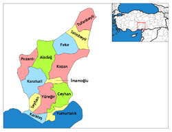
Aladag, Adana
Aladag, formerly Karsanti, is a town and district of Adana Province of Turkey about 100 km north of the city of Adana, up in the mountains. This is an undeveloped area, the people live from agriculture and forestry. People from the Çukurova retreat up here in the summer to escape the heat on the plain, although it’s too high up for a day trip.
| Aladag | |
|---|---|
| — District — | |
| Location of Aladag within Turkey. | |
Coordinates:  37°32'N 35°23'E 37°32'N 35°23'E |
|
| Country | |
| Region | Mediterranean |
| Province | Adana |
| Elevation | 850 m (2,789 ft) |
| Time zone | EET (UTC+2) |
| - Summer (DST) | EEST (UTC+3) |
| Postal code | 01720 |
| Area code(s) | 0322 |
| Licence plate | 01 |
| Website | aladag.bel.tr |
Aladag, formerly Karsanti, is a town and district of Adana Province of Turkey about 100 km north of the city of Adana, up in the mountains. This is an undeveloped area, the people live from agriculture and forestry. People from the Çukurova retreat up here in the summer to escape the heat on the plain, although it’s too high up for a day trip.
The Aladaglar mountains are an eastern extension of the Taurus Mountains. These high mountains are a popular area for climbing, usually accessed from the north through the town of Nigde. The town of Aladag sits on their southern side, accessed by road up from Adana. There is no pass through the mountains.
External links
- Head of Performance Marketing
- Head of SEO
- Linkedin Profile: linkedin.com/in/arifcagrici
Email: [email protected]
Phone: +358 44 230 0982
Worldmap1.com Blog
Copyright WorldMap1.com 2004 - 2025. All rights reserved. Privacy Policy | Disclaimer

