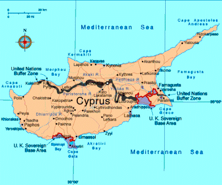
Akrotiri and Dhekelia Map
Explore the British Overseas Territory of Akrotiri and Dhekelia on the map. It is located on the island of Cyprus, this unique territory offers a blend of British and Cypriot culture. Akrotiri and Dhekelia map allows you to zoom in and out, search for specific locations, and toggle between different map layers. Use it to plan your trip, research the geography of this fascinating region, or learn more about its history.
Akrotiri and Dhekelia Map FQA
How many cities are in Akrotiri and Dhekelia ?
Akrotiri and Dhekelia are British Overseas Territories, no major cities, but main settlements are Akrotiri village and Dhekelia garrison area.What are the major geographical features of Akrotiri and Dhekelia ?
Akrotiri and Dhekelia, British Overseas Territories on Cyprus, feature coastal plains, rocky coastlines, and low hills. The terrain includes salt lakes, agricultural land, and dry Mediterranean landscapes.AKROTIRI AND DHEKELIA MAP

WHERE IS AKROTIRI AND DHEKELIA IN THE WORLD

AKROTIRI DHEKELIA CYPRUS UK MAP

Can I download a high-resolution map of Akrotiri and Dhekelia ?
Yes. Download high-resolution political and physical maps of Akrotiri and Dhekelia for personal or educational use. Redistribution is subject to the terms of our license.Where is located Akrotiri and Dhekelia on the Map
Akrotiri and Dhekelia are British Overseas Territories located on the southern coast of the island of Cyprus, in the eastern Mediterranean Sea. The two territories are both enclaves within the internationally recognized Republic of Cyprus, which is a member of the European Union. Akrotiri and Dhekelia are located on the Akrotiri Peninsula and occupy a total area of approximately 254 square kilometers (98 square miles). To find Akrotiri and Dhekelia on a map, you can look for the coordinates 34.5900° N, 32.8578° E.
Welcome to our map of Akrotiri and Dhekelia, a British Overseas Territory located on the island of Cyprus. This unique territory offers a fascinating blend of British and Cypriot culture, with a rich history and a strategic location in the Eastern Mediterranean.
Our interactive map allows you to explore the geography of Akrotiri and Dhekelia in detail, with the ability to zoom in and out, search for specific locations, and toggle between different map layers. Whether you are planning a trip to the region or simply interested in learning more about its history and geography, our map is a valuable resource.
As you explore the map, you will discover a range of interesting features and landmarks, from the stunning coastline and beaches to the ancient ruins and modern military bases. You can also learn more about the history of Akrotiri and Dhekelia, which has been shaped by the influence of many different civilizations over thousands of years.
We invite you to explore Akrotiri and Dhekelia with our interactive map, and discover all that this unique territory has to offer.
For more about Akrotiri and Dhekelia >>
Brief information about Akrotiri and Dhekelia
Akrotiri and Dhekelia is a British Overseas Territory located on the southern coast of Cyprus. The territory consists of two military bases, which were retained by the British after Cyprus gained independence from the United Kingdom in 1960. The bases cover a total area of approximately 254 square kilometers (98 square miles).A Collection of Akrotiri and Dhekelia Maps and Akrotiri and Dhekelia Satellite Images
AKROTIRI AND DHEKELIA MAP

WHERE IS AKROTIRI AND DHEKELIA IN THE WORLD

AKROTIRI DHEKELIA CYPRUS UK MAP

AKROTIRI AND DHEKELIA CYPRUS MAP

AKROTIRI AND DHEKELIA EARTH MAP

AKROTIRI AND DHEKELIA POLITICAL MAP

AKROTIRI DHEKELIA CYPRUS MAP

AKROTIRI SOVEREIGN BASE AREA CYPRUS MAP

AKROTIRI AND DHEKELIA CYPRUS MAP

AKROTIRI AND DHEKELIA SATELLITE IMAGE

MAP OF AKROTIRI AND DHEKELIA

MAP OF AKROTIRI AND DHEKELIA

- Head of Performance Marketing
- Head of SEO
- Linkedin Profile: linkedin.com/in/arifcagrici


